The route is reversible, one-day, mainly passes along the mountain range Polonyna Borzhava. The length of the ridge on this section is about 7 km. The mountain range along its entire length has steep slopes, in some places up to 60 degrees. The width of the ridge in places from 50 to 10 meters. The route to Stoy passes through the top of Velykyi Verkh (altitude 1598 meters).
The height of Mount Stoi is 1,681 meters. Mount Stoi is located in the north of the Zakarpattia region, in the southwestern part of the Polonynsky Range. The top is radial, with an almost horizontal platform up to 100 meters in diameter. At the top is a five-meter reinforced concrete memorial stele. Here are the remains of a stationary radar installation that operated during the Cold War. From the peaks of Stoy, Velykyi Verkh, there is a beautiful panorama of forests and peaks of the Polonyno-Borzhavsky ridge. Movement along a narrow strip of mountain range gives the impression of flying over forests and mountain glades, streams and villages of the Carpathians.
The complexity of the route largely depends on weather conditions. In bad weather you need to be extra careful, you need to keep a tight group on the road, at a distance of visibility in front of a partner. Also, be prepared for sudden gusts of wind. Complications of the route can be caused by the presence of snow on the slopes and trails (usually in April and May). However, the path to the top, paved over the years, makes it much easier to navigate in bad weather.
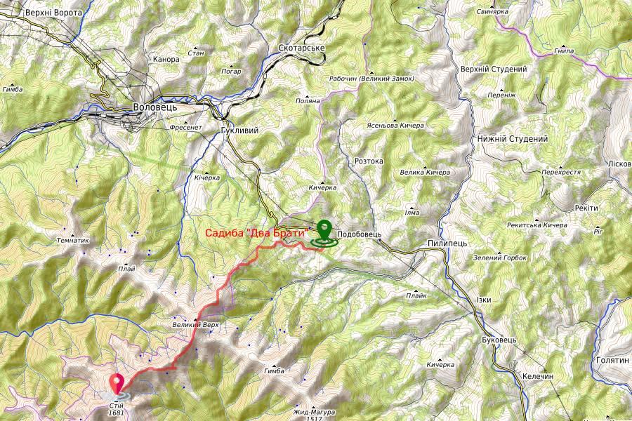
Get to the village. The day is more convenient by car or shuttle bus from m. Svalyava, Volovets or Mizhhirya township. From the cities of Uzhhorod, Mukachevo, Svalyava it is necessary to use the highway Chop – Kyiv (M 06, E 573, E 50) in the direction of the cities of Lviv, Kyiv (northeast direction). In the village. Lower Gate, at the checkpoint, turn right, in the direction of Volovets (highway T 07 18). For tourists moving from the city. Lviv in the direction of Chop (western direction) on the road M 06, E 573, E 50, turn left in the village of Nizhni Vorota in the direction of the sign – “Volovets” (highway T 07 18). At the 25th kilometer of the Nizhni Vorota – Volovets – Mizhhirya highway (highway T 07 18), in the village of Podobovets (after the bus stop) turn right (for those tourists traveling from Mizhhirya – turn left) in the western direction.
We recommend starting the route from the village of Podobovets, Mizhhia district. One of the options: stay in the estate “Two Brothers”. There is parking under video surveillance, the opportunity to hire an instructor through the owner of the estate (do it in advance), the hut, and actually for self-preparation in the cottages on each floor there are kitchens, shop (which may be useful).
For the group arriving by rail to the village of Volovets will be useful option from the owner of the estate – to meet at the station, and at the end of the route to take to the station.
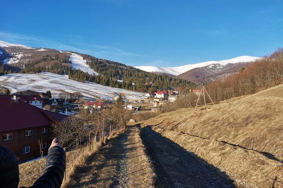
It is best to go on the route at sunrise. Direction at the exit from the estate to the left, after 500 meters turn right onto a dirt road, at the exit from the village, pass by private gardens and after 200 meters exit to a relatively flat space, from which you can clearly see the village. Daily.
The dirt road turns into several paths, which rise steeply, winding between bushes and trees. Moving to the southeast, we pass next to the cable car, cross a small strip of forest and go to the bare ridge of trees, which leads to two peaks: the Great Top and Stoi. Then the route continues in a southerly direction, the top of the ridge. Smooth ascents alternate with sharp descents. In 1 year. 30 minutes (sometimes 2 hours) the top of the mountain Velykyi Verkh (height 1,598 m above sea level) appears ahead. At the very top of the Big Top is a small metal structure in the form of a pyramid. Here you can make a stop. From this place in clear good weather to the north you can see the village of Volovets, the village of Guklive. To the northeast is Mount Thematic (1,343 m above sea level). In the south-western direction at the end of the curving mountain range, you can see the top of Mount Stoi. In this direction (185 °) it is necessary to go. Travel time from one mountain to another takes about two hours. In conditions of poor visibility it is necessary to move strictly on the path passing through the top of the ridge. At a distance of about 500 and 1000 meters from IN. The top of the ridge goes down twice steeply and also rises sharply to the usual heights of 1500 – 1550 meters.
500 meters before the top of Stoi the trail turns from the ridge to the left to the south. Passing the traverse of the southern slope of the mountain in 30 minutes. you will definitely go out on a dirt and rocky road, which goes to the right up to the top.
The last leg of the way to the goal is quite steep. At the top of Mount Stoi you can see the remains of a former military strategic facility. The return road to the village of Podobovets may follow the same route that led us to Stoi. However, the passage of the second part of the route can be somewhat facilitated by descending to the lower traverse of the northern slope of the ridge. At a distance of about 700 meters from the top of Stoi, on the first depression of the ridge you can go down from the usual path to the left (northwest direction) to the path that goes down. Then the trail leads to the traverse road, which is more convenient for quiet walking. In two hours the road will lead to the initial part of the mountain range, on both sides of which rises the forest. From here to the beginning of the route no more than two hours.